Rare Bird Data
The Rare Bird Data is a new addition to the Roberts' Multimedia. The rare birds
have a pink distribution and / or red dots. Each of the red dots indicates where
a rare bird was seen. Sometimes the rare bird was seen multiple times at the same
location and will therefore have one red dot for that locality. Over a thousand
source references were used to gather the records that appear in the program (see
Introduction Section 3.5.2). The rare bird data can be viewed by clicking on distribution
map. This links directly to the rare bird data in the text for the bird that is
selected.
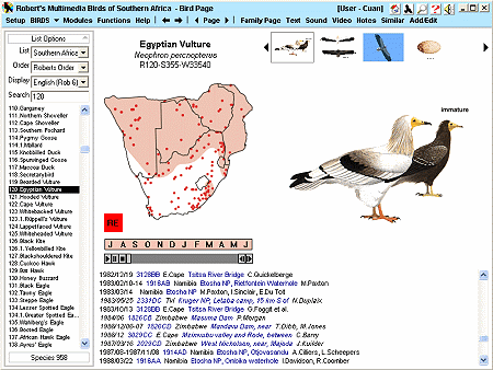
The data follows the format below:
- Date, QDS
(Quarter Degree Square), Region, Locality,
Observer
example 1 - 2001/11/04 1916AB Namibia Etosha NP, Rietfontein Waterhole L.Hansson
example 2 -1998/03/22 2127AD Botswana Shashe M.Toland
Rare bird records in
standard type are confirmed records either
accepted by a rarities committee or records of dead birds or of birds taken into
captivity. Records in italics are unconfirmed records, some of them only
tentatively identified. Only records of birds within or up to 200 nautical miles
offshore of the Southern African region, which have not been rejected by a rarities
committee and are not known to have been held in captivity, are included.
Dates are given in the form
year/month/day. For example, 21 January 2001 is given as 2001/01/21. Some dates
may be imprecise - for example, 2001/01 means January 2001. Summer 2001, given
by 2001/summer, is taken to mean the summer starting in 2001 and ending in 2002.
Approximate dates start with 'c'.
If a bird was recorded
for a period of time, the first and last dates on which it was recorded are given
separated by a hyphen '-'. For example, if a bird was recorded from 21 January through
to 13 February 2000, its date will be 2000/01/21-02/13.
If it is not known exactly
when a bird was recorded then the earliest and latest dates on which it could possibly
have been recorded are given, separated by a tilde '~'. For example, if a record
is given in a bird atlas for which field work was carried out between 1987 and 1992,
its date would be 1987~1992; if a bird was recorded during a trip which lasted from
21 January until 13 February 2000, its date would be 2000/01/21~02/13.
If the earliest date
on which a record could have been made is not known then the date of publication
is given, preceded by the character '' which indicates that the record could have
been made at any time up to and including, but no later than, the given date.
For example, an undated record published in October 1943 would be given the date
1943/10.
If the time of year
(day, month or season) on which the bird was recorded is known but the year is not
then the time-of-year information will be given after the year information, separated
from the year(s) by a comma. For example, if a bird was recorded on 21 January
but the year could have been any year up to 2001, the date will be 2001,01/21; if
a bird was recorded at some time between January and March (inclusive) in some unknown
year between 1970 and 1980, the date will be 1970~1980,01~03; and if a record is
given as "recent" in a source published in 1980 then its date will be
1980,recent
In short:
A - B =
from date A to date B
A ~ B =
between date A and date B, not necessarily on either A or B
A = no later
than date A
A~B,C =
at the time of year C between date A and date B
A,C = at
the time of year C, no later than date A
QDS (Quarter Degree Square)
contains the approximate co-ordinates of the record in the form 2930CB. The digits
locate the north-west corner of a 1 degree rectangle on the earth (first pair =
latitude; second pair = longitude) and the two letters successively subdivide this
rectangle into quarters. A and B are the top left and right quadrants, respectively,
and C and D are the bottom left and right quadrants respectively.
For example, 2930CB
is the top right quadrant (B) of the bottom left quadrant (C) of the 1 degree square
area bounded on the northern side by the 29th parallel South and on the western
side by the 30th meridian East.
If the letters are in
lower case (e.g. 2930cb) then the QDS is very approximate: it refers either to the
centre of the Locality, if the Locality is bounded (e.g. Hwange NP), or to an estimated
point if the Locality is unbounded (e.g. Off Cape Point). Such estimated co-ordinates
are only listed and plotted when a more precise locality could not be found.
Region,
the country or South African province in which the bird occurred, is abbreviated
as follows:
OFS = Orange
Free State
E.Cape =
Eastern Cape
W.Cape =
Western Cape
N.Cape =
Northern Cape
Tvl = former
Transvaal (Gauteng, North West, Limpopo and Mpumalanga provinces)
KZ-Natal = KwaZulu-Natal
Locality
indicates where in a Region the bird occurred. It may be missing from very vague
records which only specify a Region and from bird atlas records which have a QDS
but no Locality name. Commas indicate that the following phrase qualifies the preceding
phrase. For example:
"Algoa Bay, Bird
Island" means "Bird Island in Algoa Bay"
"Amanzimtoti, 12
km E of" means "12 km East of Amanzimtoti"
"Upington and Poffadder,
between" means "between Upington and Poffadder"
"Bapsfontein, near,
Dicken's Pan" means "Dicken's Pan which is near Bapsfontein"
"Paarl, W of, Joostenbergvlakte
area" means "Joostenbergvlakte area which is West of Paarl"
"Moremi NP, Tsaro
Camp, 1 km W of" means "1 km W of Tsaro Camp in Moremi NP"
The following abbreviations
are used: NP = National Park; GR = Game Reserve; NR = Nature Reserve; Mt. = Mount;
km = kilometres; m = miles; nm = nautical miles.
Observers
are some of the people who recorded the bird. If the order of sightings is known
then the first observers are listed; otherwise the observers are listed in the same
order as in the source reference with the author of the source listed first. "et
al." indicates that other people also saw the bird.
unconfirmed example:
2001/11/04 1916AB Namibia Etosha NP, Rietfontein Waterhole L.Hansson
confirmed example: 1998/03/22 2127AD Botswana Shashe M.Toland
|